The view from here

10 06 2018

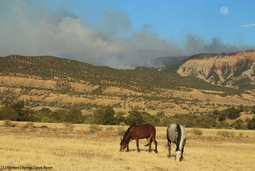
The 416 Fire (north of Durango) from Disappointment Valley.

The 416 Fire (north of Durango) from Disappointment Valley.

Ugly.

The 416 Fire north of Durango has surpassed 8,600 acres and is still only 10 percent contained. The Durango Herald reports that more homes have been evacuated (now more than 1,300) and additional homes are on pre-evacuation notice (more than 1,000). The Burro Fire, in Montezuma County about 13 miles west of the 416 Fire, is at about 300 acres and 0 percent contained.

If it looks like this from Disappointment Valley, can you imagine how terrifying it looked from Durango?

It’s hard to imagine the searing fear one must feel if your home is in the area of this – or any – fire.

Though it takes away none of that fear … please be safe.


More wildfire news

2 06 2018

Terra

Firefighters on the Horse Park Fire have hit the astounding mark of 90 percent containment as of Friday night. Amazing work! We continue to send our thanks to these hardworking men and women.

But in other wildfire news … our prayers are with residents north of Durango who have been evacuated from their homes and/or are on pre-evacuation notice for the 416 Fire. Our friends with Four Corners Back Country Horsemen are helping evacuate horses.

Follow La Plata County Government’s Facebook page for updates about the 416 Fire.

It’s a scary dry world out there. Safety precautions cannot be overstated.

The Forest Service has enacted Stage 2 fire restrictions on San Juan National Forest land in Southwest Colorado, and BLM Tres Rios’ Stage 2 fire restrictions begin Monday, June 4:

STAGE 2 FIRE RESTRICTIONS begin in the BLM TRES RIOS FIELD OFFICE on MONDAY, JUNE 4
The following acts are prohibited under Stage 2 Fire Restrictions on BLM lands:
• Building, maintaining, attending or using an OPEN FLAME, including fire, campfire, stove fire, charcoal grills and barbecues, coal and wood burning stoves, and devices (stoves, grills or lanterns) using liquid fuel such as white gas or kerosene. This prohibition applies to all public lands within the Tres Rios Field Office and Canyon of the Ancients National Monument, including Wilderness Study Areas and developed camping and picnic grounds in Archuleta, Dolores, La Plata, Montezuma, Montrose, and San Miguel Counties.
• Exception: Operating a stove, lantern, or other device using pressurized gas canisters (isobutene or propane) equipped with a valve that allows the operator to immediately turn the flame on and off.
• SMOKING.
• Exception: Within an enclosed vehicle, trailer or building.
• WELDING or operating acetylene or other torch with open flame.
• Using an EXPLOSIVE. This includes but is not limited to fuses or blasting caps, fireworks, rockets, exploding targets, and tracers or incendiary ammunition.
• Operating a CHAINSAW without an approved spark arresting device, a chemical pressurized fire extinguisher (8 oz. capacity by weight or larger and kept with the operator) and a round point shovel with an overall length of at least 35 inches readily available for use, or outside of the restricted hours of 5am – 1pm.
• All TARGET SHOOTING – To include Discharging a FIREARM, air rifle, or gas gun.
• Possessing or using a MOTOR VEHICLE OFF ESTABLISHED ROADS, motorized trails or established parking areas, except when parking in an area devoid of vegetation within 10 feet of the vehicle.
• Except for parking overnight in developed campgrounds and trailheads.
• The use of fireworks, flares, or other incendiary devices, including exploding targets, are always prohibited on federal lands.
These restrictions include Bureau of Land Management Tres Rios Field Office and Canyons of the Ancients National Monument including BLM managed lands in Archuleta, Dolores, La Plata, Montezuma, Montrose, and San Miguel counties.


80 percent containment!

1 06 2018

Sunset

According to Inciweb, the Horse Park Fire is now 80 percent contained!

It lists the estimated containment date as July 9. I incorrectly had June 9 in yesterday’s post. Who could blame me? Those firefighters are rockin’ their efforts on this fire.

It was pretty warm and VERY windy again, so firefighters are dealing with some rough conditions. I saw a couple of helicopters ferrying water over the fire today, as well as, for the first time, a Chinook-type helicopter. This Army brat loves seeing those big boys. 🙂

The horses are doing fine. One benefit of the wind is that the basin is pretty well clear of smoke.


Horse Park Fire now on Inciweb

31 05 2018

Skywalker; Horse Park Fire

Another link for ya’ll: The Horse Park Fire is on Inciweb.

The fire is at 1,240 acres and 50 percent contained! Two hundred seventy-two people are working on this fire, and we thank each and every one of them! They estimate containment by June 9.

The smoke was much reduced Wednesday, even from the last couple of days.

And more good news: We got a few drops of rain. 🙂 I think one of the fire reports said no rain fell over the fire, but it was cooler, and we had cloud cover. The weather is supposed to change (not for the better), so this hopefully gave firefighters a good day to make advances. The report note that the moisture in the dead logs in the fire area is about 3 percent; kiln-dried wood has about 15 percent moisture. Yikes.

It’s hard to overstate how terribly dry it is. Please, please, be careful.


Fighting the Horse Park Fire

30 05 2018

052718comanchefire1a

The smoke as of Tuesday is way less from the Horse Park Fire as many more firefighters are arriving to work on it. This photo is from Sunday evening as Comanche paused while grazing. You can see the lines of red retardant on the far ridge below the smoke where the air tankers were dropping it along the fire’s edge.

Update: I wanted to add this link to a Facebook page specifically for the Horse Park Fire.

Some more links to information about the Horse Park Fire:

Cortez Journal article

Wildfire Today


Acreage greater, smoke less

29 05 2018

052718templemadisonfiremoon1

The Horse Park Fire was fairly quiet today in terms of visible smoke. The firefighting effort continues from the air, and that seems to be having a good effect. The fire is up to about 1,500 acres.

For fire updates – including a pretty haunting video (scroll down under “Tweets”) – visit the webpage for San Miguel County Sheriff’s Office.

If you’re on Facebook, follow the sheriff’s office Facebook page for updates.

We send our thanks to all those involved with the firefighting efforts.

Rain dances are ALWAYS appreciated. 🙂


Horse Park Fire

28 05 2018

The first thing to know is the most important: Spring Creek Basin’s mustangs are OK.

Horse Park is immediately north of Spring Creek Basin. The Horse Park Fire started Saturday night by a lightning strike, and firefighters were on it pretty much immediately. The fire is outside the basin’s northeastern boundary and moving basically northward, pushed by strong winds from the south/southeast.

Early in the day, I was with Steve Heath (Heath Water Service) in the basin to show him the  roads. There’s a big difference in go-to-ability between his loaded water truck and my nimble Jeep, and we wanted to see where he can go with his truck to deliver water farther into the basin than the catchment when the drought situation requires it.

Good news on that front, too: Steve is confident that he can get his water truck to the places where we might set water troughs for the horses (in addition to the water catchment).

It was interesting – and a little (a lot) sobering – that while we were scouting for water locations, this fire blew up on the basin’s northeastern horizon. As of the 10 o’clock news on the Denver CBS 4 station, the Horse Park Fire was at 1,000 acres with 0 percent containment.

Following are some photos from the day:

052718horseparkfire1

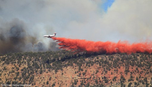
Several planes were in the air all day, small planes like this one (above) and big planes like the one below:
052718airtanker2

Part of the fire was in McKenna Peak Wilderness Study Area, where fire retardant is forbidden, one of the BLM fire guys told me. Once the fire moved north from the WSA, three big air tankers started dropping the familiar red material.

052718airtanker3

This is the same plane as the closer photo above, a few seconds later. Looks pretty crazy, huh?
052718choppermcktb1

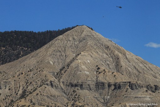
At least two helicopters were carrying water buckets from what appeared to be numerous sources to sites that were burning on top of the ridge. The main feature here is McKenna Peak. Perfectly placed behind McKenna from this vantage point (the eastern end of roller-coaster ridge), Temple Butte is mostly blocked. The fire is to the left – north.
052718BLMfirefighters1

052718BLMfirefighters2

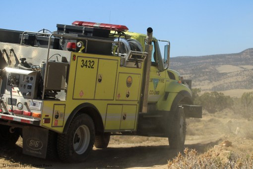
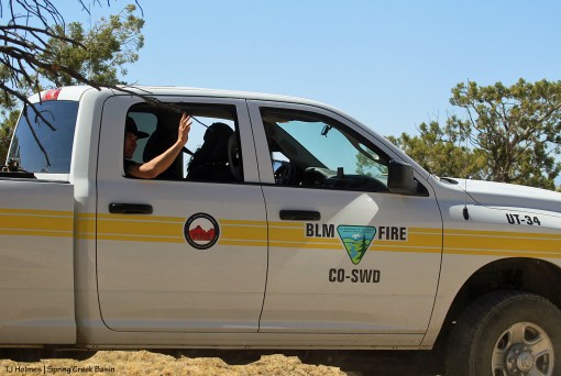
I was glad to find these guys on roller-coaster ridge, watching the fire from the basin side. Crew leader Dan was helpful with information, as was Patrick Seekins, BLM fire management officer, who called within 15 minutes of me calling dispatch in the morning to report the smoke. They had been aware of the fire and mobilizing pretty much since it started the previous night.

Unofficially, by my observations and from information given by Patrick and Dan, there was a lot of activity on this fire: a crew of smoke jumpers and a crew of hot shots; a fire team out of Norwood; BLM firefighters from Dolores; three big air tankers (resupplying in Durango, Cortez and Grand Junction, I think Dan said); at least four, maybe five, smaller planes dropping retardant; at least two helicopters carrying water buckets; at least one aircraft coordinating all the others (there were a lot of “birds” in the sky!).

Here’s a link to an article about the Durango Air Tanker Base in The Durango Herald. Planes like the one pictured with the article definitely were flying above the Horse Park Fire and dropping retardant.

It is incredibly dry out there in this land of no rain. Really, really, REALLY dry. This is not the first fire in the region, and it won’t be the last.

Fire restrictions are in place pretty much everywhere. PLEASE be super careful.

S'aka, Horse Park Fire

I asked Dan to please pass along to his colleagues the thanks of Spring Creek Basin’s mustangs and their human admirers. 🙂 There seems to be very little chance that the fire will burn down into the basin, but it’s close enough to raise the anxiety level.

The mustangs are in good shape – living in the moment, doing what they do. 🙂

P.S. Happy Memorial Day. It is a day to remember the service of others! Thankfully, those in my family who served their country came home. Today, we remember and honor those who did not make it home to their loved ones.


Prayers

2 07 2013

For the 19 Granite Mountain Hotshots firefighters who died in Arizona.

For their sacrifice and efforts to help others.

For their families.

It is so terribly dry in many parts of the West right now. Please use care and caution when traveling and playing and enjoying the outdoors, whether in your backyard or on public lands.

To all the firefighters working to save the homes and properties of others from wildfires human- or nature-caused, thank you. Be safe.


Water for mustangs

30 06 2013

Not elephants. Although, as this drought continues, it’s beginning to look a lot like the sere plains of Africa out here.

I call this photo “La Sals, Imagination”:

062813greyswatch

Whaddya mean you can’t see the mountains … through the smoke? Use your imagination. 🙂 Although Grey/Traveler’s band seems to also be looking for the mountains, they were watching Chrome’s band walking toward them on their way to the water catchment.

Smoke from this fire – way, way, way east of here – apparently has drifted into New Mexico then blown back north and west into Colorado. But it’s not the only fire burning in the region.

Earlier, Grey/Traveler’s band had been drinking at the water catchment’s trough:

062813greystrough

Maia, clearly at her leisure, worried me; I thought the worst, that the storage tank had drained and the trough was empty, and she was waiting for someone to come fill it, darnit!

Not to fear.

Water trough at the catchment in Spring Creek Basin, looking toward the road.

The trough was full of water. Whew. (The big green tank is the storage tank that holds water from either rain or snow or direct-fill.)

Because of the drought, BLM has been checking to ensure that the horses have enough water sources, and we – National Mustang Association/Colorado – recently got the green light to deliver a load of water – 4,000 gallons – to the catchment tank. Donors and silent-auction-item buyers at the Pati Temple Memorial Benefit Bash, this is the first use of the money you helped us raise! Interestingly, the area of the catchment is used primarily by Chrome’s band and rarely by other bands. But some other bands have started to find the water – and the good forage in this area. Water is a good way to disperse the horses’ grazing and get them to use under-used areas.

062813chromesdrink1

Chrome’s band at the catchment trough, drinking clean water. This is an important water source because it’s the only clean source of water in the basin. The others are high in alkalinity and salt because of the basin’s soils. The dusky, hazy color cast is because of the smoke.

The temperature hit 110 degrees Friday. On Thursday, the high was 108. Smoke, wind, heat, zero moisture = ugh.

Cecil Foster, owner of Foster’s Water, to the rescue.

062813watertank2

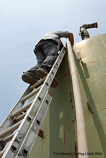
The storage tank is about 15 feet tall, so Cecil brings his ladder to access the hatch at the top. At right is the hose from his water truck.

062813watertank3

Seen here are his water truck, the hose to the tank and the water trough in the background at right.

062813watertank1

Thanks, Cecil! He also donated a load of water for the benefit’s silent auction. Cecil is a super nice man, and a friend of the mustangs of Spring Creek Basin.

Thank you, NMA/CO, for the delivery of water to the mustangs!


Fire tree update

19 07 2010

The tree fire is long out. While we’re scorching now in Southwest Colorado (and elsewhere – Denver hit 100 Saturday, even as did Cortez, straight south of the basin as the raven flies), we had rain awhile back, and it’s likely that doused the flames on the tree fire I reported almost two weeks ago.

The fire management officer from the Dolores Public Lands Office (who coordinates both Forest Service and BLM crews) was super nice and met me last week to make the long drive to the basin and have a look. What he could tell us would fill a book (and likely does somewhere, for aspiring young wildland firefighters), but the upshot is the basin would probably never suffer from a catastrophic wildfire because there simply are not the “combustibles” to fuel it (my word – I’m pretty sure he never said that actual word :)).

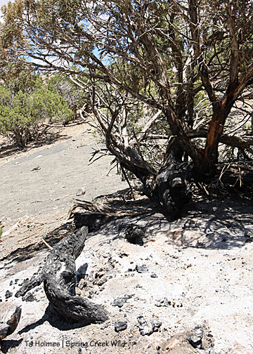
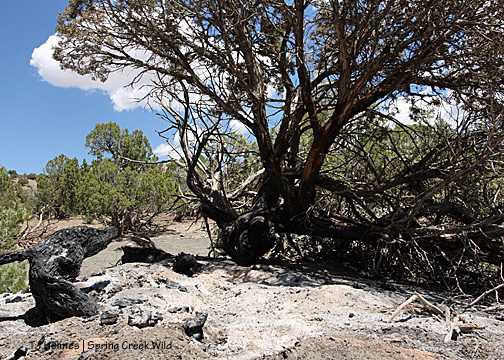
Here’s the “overall” scene. The tree that burned is fringed with brown on its needles – sort of middle/upper right. The dead branch in the foreground at right also burned, as well as the black stump you can barely make out just left of center, as well as some other branches that apparently were consumed by their respective fires. See the little green tree immediately behind the black stump? It’s hard to tell how close it is, but it’s close. That’s pinon – the tree that burned is Utah juniper (I also learned the difference between Rocky Mountain and Utah juniper) – and it wasn’t touched, apparently. But then see what looks like the dead, fallen trunk at far left? It’s attached to those singed needles you see at upper left (against the blue sky). That likely came from the fire, but the tree as a whole should live – even though it looks like it’s on the ground. So did the tree that burned before the fire burned through its horizontal trunk and put the “crown” on the ground, where it fell on another little bush with round little leaves … not a pinon or juniper. I imagine that poor little thing is toast. But hopefully you can also see in this picture, beneath the scattered woodsy debris (I’m surprised it didn’t burn), is grey dirt – which is sort of a mix of dirt and shaley rock – very fine – you can hear it crunch and crackle when you walk over it. And you can maybe get a sense of how far apart the trees are in this area. The FMO did note areas he thinks have burned previously, but grass may never take hold here – not well – because of the poor alkaline soil.

Between the near black stump (hard to see in the first picture) and the rest of the tree used to be the trunk, which burned completely and totally through and away. See where the bark of the tree looks skinned away? The FMO said that’s the path of the lightning strike. Not really a “scar” as much as it just burned from the top to the bottom through that “papery” layer of bark – basically, it’s “firestarter” – kindling.

Nature at work.

Be careful out there while you’re camping this summer. It seems like many places in the country are feeling the heat this summer, and particularly in the West, ’tis the season for fires – wild and otherwise. Some local Back Country Horsemen, out for a ride in the national forest close to where I live and have been mountain biking, were out for a day ride recently and came across a campfire someone(s) had left burning! (By the accompanying pictures, it was big.) Let’s have a collective gasp for the stupidity factor! Bless those horse folks for giving up ride time to not only put out the fire but CLEAN UP THE TRASH left behind! This was a possible disaster waiting to happen – many ponderosa pine trees and Gambel oak – forest – in other words, loaded with “fuel.” There are homes in the area, and it’s a popular recreation entry point to the forest for locals.

My thanks again to the FMO for coming out to the basin and enhancing my education about natural forces – which include fire. Here in the basin, the outcome was hopefully more benefit than disaster (maybe birds will make use of the tree as it decays … maybe some grasses will spring up in spite of the soil …). We even saw a few horses: Chrome’s band let us squeak by on the road pretty close, and Seven’s, Grey/Traveler’s and Hollywood’s were visible at distances in different areas.

Circle of life. 🙂