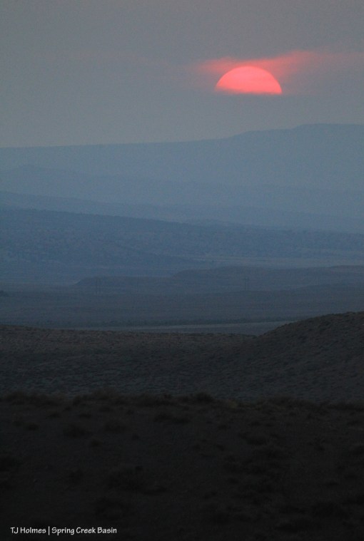
Still hot.
Still dry.
Still smoky.
Still hot.
Still dry.
Still smoky.
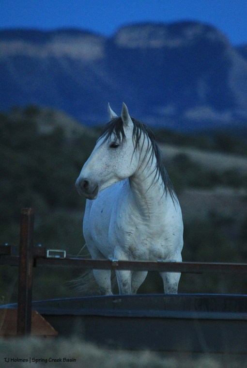
Tenaz surveys his world against a backdrop of Spring Creek canyon, lower Disappointment Valley and Utah beyond.
Some of you may have received an email from Tres Rios Field Office Manager Connie Clementson regarding an EA now out for public comment about bait trapping in Spring Creek Basin. If you didn’t, you can follow this link to DOI-BLM-CO-S010-2015-0001-EA (Spring Creek Basin HMA Bait Trap Gathers).
At the above website, you will find links to the “public notice: opportunity to comment” letter as well as the EA. You’ll also find this summary of information:
The BLM is analyzing the environmental effects of removing wild horses by bait and/or water trapping in a site-specific analysis of potential effects that could result with the implementation of a proposed action or alternatives to the proposed action.
Background
In August 2014, the Bureau of Land Management (BLM) Tres Rios Field Office (TRFO) received a Bait Trapping Proposal for future removal of excess wild horses from the Spring Creek Basin Herd Management Area (HMA) from Kathryn Wilder, TJ Holmes, Colorado Chapter of the National Mustang Association, Four Corners Back Country Horseman and the Mesa Verde Back Country Horseman [collectively known as Disappointment Wild Bunch Partners].
The proposal is for the BLM to use bait and/or water trap methods for future removal activities of excess wild horses within the Spring Creek Basin HMA located in Disappointment Valley, Colorado. ***It should be noted that the BLM TRFO is not proposing to remove any excess wild horses from the HMA at this time.***
The purpose of the proposed action is to implement the use of bait and/or water trapping methods for removal of excess wild horses within the Spring Creek Basin HMA in order to maintain a thriving natural ecological balance with healthy sustainable rangelands by maintaining the appropriate management levels (AML).
The proposed action is needed because, at some future date, the BLM may determine that the number of wild horses on the range within the Spring Creek Basin HMA exceeds the established Appropriate Management Level (AML), and horse gathering is necessary in order to maintain the population at an appropriate level in balance with the ecosystem.
Decision to be Made
The BLM will decide whether or not to use bait and/or water trapping as the preferred gather method for removing excess wild horses from the Spring Creek Basin HMA. This analysis and subsequent decision will be utilized for future gathers over the next 10 years.
Project Location
The Spring Creek Basin Herd Management Area is located between Norwood and Dove Creek, Colorado in the Disappointment Basin. The main access is from the west via San Miguel County Road 19Q (also known as Disappointment Road).
*****************************************
*** Do NOT overlook this very important sentence: “It should be noted that the BLM TRFO is not proposing to remove any excess wild horses from the HMA at this time.” (Emphasis, mine.)
This, dear readers and wonderful supporters of Spring Creek Basin’s mustangs, is a good thing.
As noted, in 2014, we submitted a proposal to BLM to consider bait trapping above all other methods of rounding up and removing mustangs from Spring Creek Basin. In other words, bait trapping over helicopters. That led to a scoping period, during which BLM received 8,000 letters (give or take) favoring bait trapping over helicopters (thank you!).
Here’s the thing: Spring Creek Basin MUST be able to support its mustangs.
To great effect, we are using native PZP (one-year fertility-control vaccine) to slow population growth (because, as you undoubtedly know, PZP works where PZP is used). Given the fact that it is 2018, our last roundup was in 2011, and still NO HORSES ARE SLATED FOR REMOVAL FROM SPRING CREEK BASIN, I’m going to underline our successful use of PZP.
However, that doesn’t mean that we may never need to remove some horses for the continued range health of Spring Creek Basin, which is the absolute foundation of the health of our mustangs (of course, our priority is to manage our wild horses in the wild, on their home range).
This EA is the culmination of years of work by our groups (see above, noted by BLM) to make bait trapping the preferred method of gathering (yes, I’ll use that term with regard to bait trapping), as opposed to helicopter driving.
This EA does NOT mean the removal of horses from Spring Creek Basin is imminent; it DOES mean BLM wants to use bait trapping here instead of helicopters – IN THE FUTURE, WHEN NEEDED (also mentioned in the summary above) – and BLM wants your public comments to cement the deal.
We hope you’ll support us as we support our mustangs AND our local BLM folks who work closely with us toward that goal: Connie Clementson (manager, Tres Rios Field Office), Mike Jensen (herd manager extraordinaire (his official title is rangeland management specialist)) and Garth Nelson (rangeland management specialist who works with Mike and with us). (Special shout of note to former range tech Justin Hunt, now working for the recreation folks at TRFO. We’re sure – and glad – that we haven’t seen the last of him.)
The deadline for comments is Aug. 27, 2018. Please do comment favorably about bait trapping in Spring Creek Basin (in the future, when needed): Alternative A – proposed action: “The proposed action would utilize bait/water trapping as the primary gather method to remove excess wild horses from the HMA. No wild horses would be removed as long as population was or remained within AML.”
Even if/when removing some horses – for the good of the herd and the range – becomes necessary, we want to ensure that it happens in the best possible way for our beloved mustangs.
Please let me know if you have any questions. (You can query in the comment section, or leave a comment asking me to email you.)
Huge thanks. 🙂

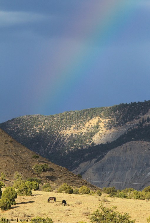
Sweet Dolly Parton, I have two bones to pick with your lovely quote: “The way I see it, if you want the rainbow, you gotta put up with the rain.”
1) There’s the assumption there that rain is bad or something to be tolerated.
2) Really, you don’t have to have rain to have a rainbow.* Nearly never do we actually get rain with our rainbows in Disappointment Valley.
GIVE US THE RAIN! PLEASE! 🙂
* Somewhere, there must be rain, given the physics of rainbows. But rain doesn’t have to be falling on you. And, really, we would LOVE to have the rain. The rainbow is just sprinkles to the magic.

Grateful.
Some good news on the 416 Fire front from The Durango Herald.
We kept getting little waves of drizzly dribbles during the day.
Sweet. So welcome. So desperately, very welcome.


Ugly.
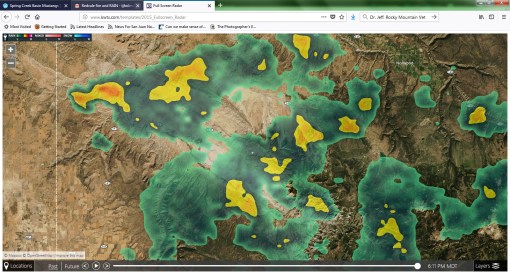
The 416 Fire north of Durango has surpassed 8,600 acres and is still only 10 percent contained. The Durango Herald reports that more homes have been evacuated (now more than 1,300) and additional homes are on pre-evacuation notice (more than 1,000). The Burro Fire, in Montezuma County about 13 miles west of the 416 Fire, is at about 300 acres and 0 percent contained.
If it looks like this from Disappointment Valley, can you imagine how terrifying it looked from Durango?
It’s hard to imagine the searing fear one must feel if your home is in the area of this – or any – fire.
Though it takes away none of that fear … please be safe.

Another link for ya’ll: The Horse Park Fire is on Inciweb.
The fire is at 1,240 acres and 50 percent contained! Two hundred seventy-two people are working on this fire, and we thank each and every one of them! They estimate containment by June 9.
The smoke was much reduced Wednesday, even from the last couple of days.
And more good news: We got a few drops of rain. 🙂 I think one of the fire reports said no rain fell over the fire, but it was cooler, and we had cloud cover. The weather is supposed to change (not for the better), so this hopefully gave firefighters a good day to make advances. The report note that the moisture in the dead logs in the fire area is about 3 percent; kiln-dried wood has about 15 percent moisture. Yikes.
It’s hard to overstate how terribly dry it is. Please, please, be careful.

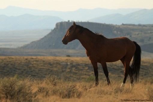
The smoke as of Tuesday is way less from the Horse Park Fire as many more firefighters are arriving to work on it. This photo is from Sunday evening as Comanche paused while grazing. You can see the lines of red retardant on the far ridge below the smoke where the air tankers were dropping it along the fire’s edge.
Update: I wanted to add this link to a Facebook page specifically for the Horse Park Fire.
Some more links to information about the Horse Park Fire:
Comanche and his band have found the “new” catchment trough (where we installed the apron and new trough two summers ago and the evaporation cover last fall).
The horses have two ponds and the two catchments as water sources, as well as numerous (if not high quality) seeps in various arroyos throughout the basin. Our BLM herd manager (Mike Jensen) is committed to closely watching the drought situation (we’re in the D4 category now – exceptional drought). Our awesome water hauler (Steve Heath) is able to pump water directly into the storage tanks. In the next week or so, we’ll be scouting locations that his water truck can reach to pump water into big troughs – supplied by BLM – elsewhere in the basin if conditions warrant.
Local ranchers have been hauling water continuously already this spring because it’s so dry.
And that wind – that howling, awful wind – is leaching away the moisture we don’t have, day after day.
It’s tough, folks, for wildlife and for livestock, and certainly not only in Disappointment Valley. That said, please know that the mustangs do not seem to be stressed. They have decent forage, as well as water sources, and they’re well dispersed throughout their range, not sticking to certain places as they would if they were stressed about sustenance/water.
Members of Disappointment Wild Bunch Partners are monitoring conditions closely, and the Colorado chapter of the National Mustang Association has offered to help pay for water deliveries to Spring Creek Basin.
We are so grateful (as always) to our Tres Rios BLM guys for being committed to the well-being of our mustangs!
For the many-th year (20?), we welcomed University of Missouri students to Spring Creek Basin once again to celebrate spring. And as absolutely always, we love these kids!
They bring their enthusiasm and energy across the country from Columbia, Mo., to Southwest Colorado, to complete beneficial projects on public land managed by the Bureau of Land Management and the U.S. Forest Service.
We started restoring Spring Creek Basin’s southeastern boundary fence, in McKenna Peak Wilderness Study Area, way back in 2012. This year, we didn’t have two work days as in years past. We didn’t get snowed out like we did the last two years (we did get a little work done those years). We DID get basically to the end of the project (the base of a steep hill where a Southwest Conservation Corps crew took over a couple of years ago).
Wow.
University of Missouri students can take proud, beautiful credit for this strong, beautiful fence, and we are SO proud of them for all the work each of these students brought to the benefit of our beautiful mustangs.
We also give a special shout out to San Juan Mountains Association’s Kathe Hayes, who is “semi-retired” and enjoying winter with her horses in Arizona. For all the years of alternative spring break’s history in Southwest Colorado, Kathe headed the program. MK Gunn has stepped strongly into those big shoes left by Kathe, and we’re happy to have her (you might recognize her from years past, helping with alternative spring break). *The title of this blog post comes from MK. 🙂
Now on to some pix.

Wild stallion Ty (see him? just right of center) made an appearance as students hiked to the work site yesterday morning.
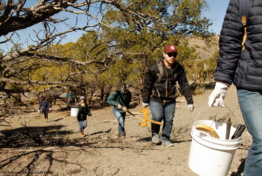
Because of the work by the Forest Service mule pack string last year, the students carried just tools in and old wire out. Pictured are Austin (with the bucket), Xavier, Jim, Erin, Gracie and a couple of others.

Our esteemed herd manager, Mike Jensen, modeled a full beard for this year’s alternative spring break. We like it! But apparently, his family doesn’t. 🙂 Erin was starting to roll a strand of old wire …
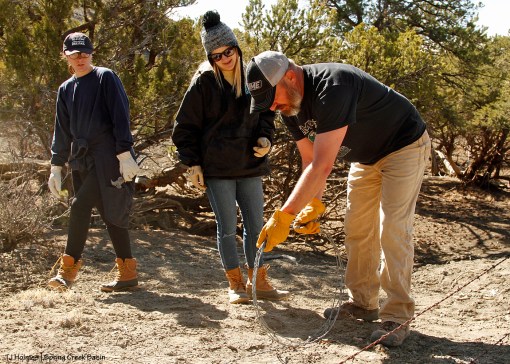
… and Mike came up the hill to show Erin and Gracie how to roll the barbed wire to get it to stick together.
And then they were pros! (If you don’t believe me, check out the last photo in this post.)

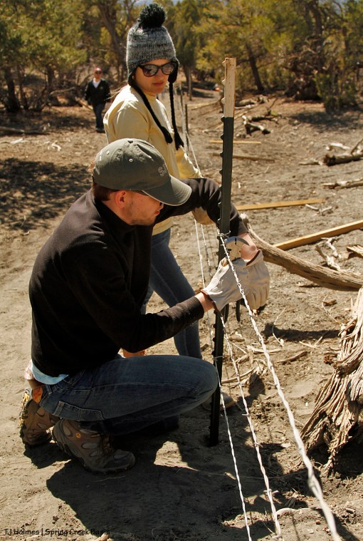
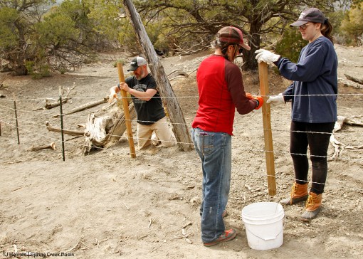
In this last stretch of fence line, we needed to remove some old T-posts and pound new ones to replace old juniper posts, so Erin stepped off the distances between posts, and Xavier dropped the posts where she indicated.

Range tech Justin Hunt (left) watches range specialist Garth Nelson as he saws off the end of the horizontal post of a new H-brace held by Mike while our trio of awesome BLM guys built the H-brace at the end of the line. The post was bolted at both ends and then cross-wrapped with wire to hold the tension of the wire strands.
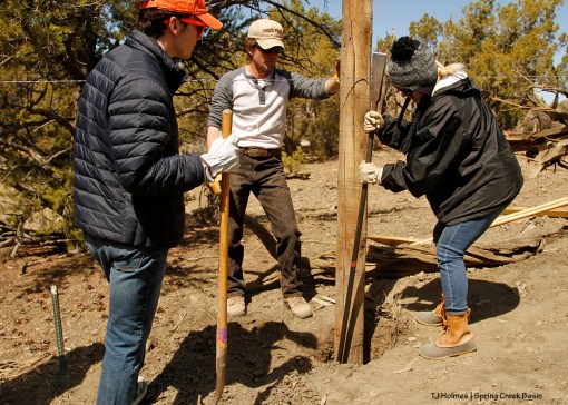
Because there was a steep little drop from the end H-brace (to the right), Justin helped Erin and Austin dig a hole for a big post to help hold the tension of the wires.

We have used these measuring sticks for a lot of years now. We start with the bottom wire and roll them out and tighten them and clip them from the bottom up. The measurements are wildlife friendly, so elk calves and deer fawns can crawl underneath the bottom, smooth-twisted wire, and adults don’t get caught between wires when they jump. The top strand also is smooth-twisted wire. The middle two strands are barbed wire, to keep cattle (outside the basin) from pushing against it.
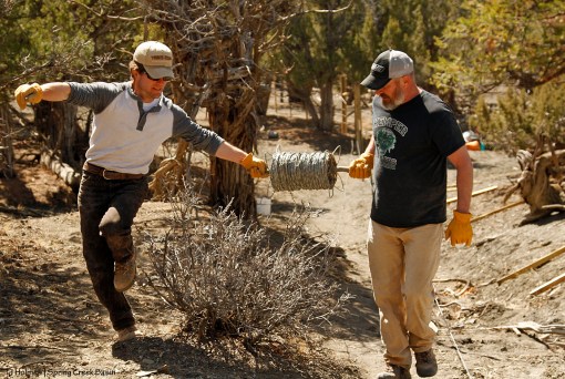
Mike and Justin unroll another strand of wire from down the hill up the hill.
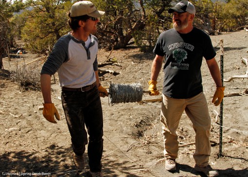
And I had to include this pic that shows the camaraderie between our BLM guys. We’re really grateful to have all three of our guys. They make the work fun. 🙂
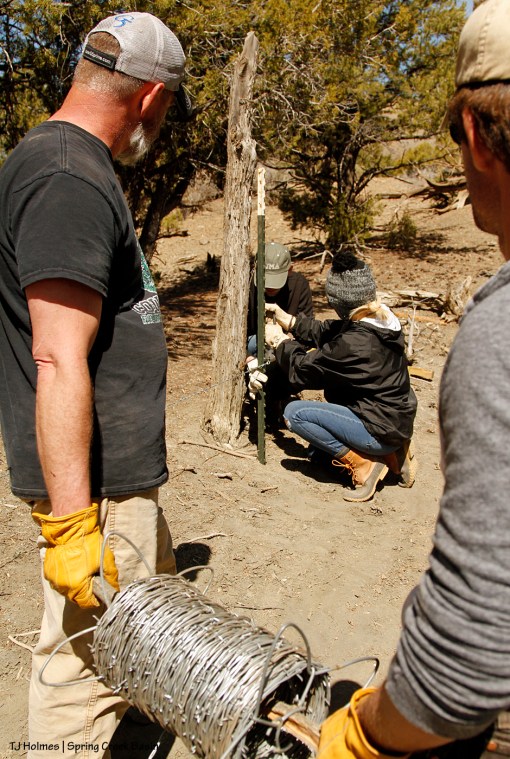
Here, Mike and Justin paused for a minute to let Erin and Jim attach a clip to the last T-post so they didn’t get tangled in the next strand. A great thing about having many hands for a project like this is that we’re always busy with the next step, and it goes really fast!
Here, Jim and Erin are up to the third wire strand. Notice the wood staves laid out on the ground along the fence. Students put those in place so they’d be ready when all the wires were tightened, clipped (to T-posts) and stapled (to wood posts).

And there’s the new fence – all four strands. Gracie and Austin are rightfully proud of their work!

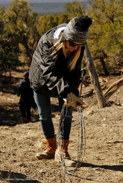
One of the last steps of the process was to cut pieces of wire in order to secure the wooden staves to the wire strands. Advocate Kat Wilder (left) helps Erin and Austin cut pieces of uniform length while Xavier visits with Jessi, one of Kat’s canine companions.
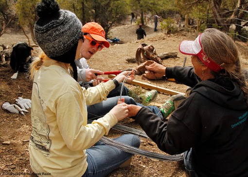
This is a closer look at the wire-piece cutting, looking down at the fence the students just built. We set up a system where the other students, MK, Garth, Justin and Mike were wiring the staves to the strands while Kat, Erin and Austin cut the wire pieces for some students to carry down the hill. They cut about 100 pieces to attach the staves in this last stretch of fence!
Gracie and MK and Mike wire staves to the fence strands. The staves help support the fence and keep the strands at the same spacing. Plus, they provide a very visible barrier for the horses and other wildlife.

The pups were definitely a hit with the students. 🙂 This is Gracie and Jessi.
Mizzou students, once again, we thank you, thank you, thank you all for your work! We love the alternative spring break program and the benefits it brings to our mustangs (and other areas of our public lands). We really couldn’t have done this without ya’ll!
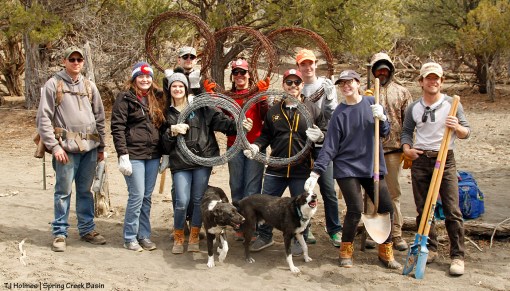
In honor of this year of the Winter Olympics, students show off the old wire rolls that they carried out of the basin at the end of their day of work. From left to right: Garth Nelson, Jessica (who is getting over being sick; we hope she feels better to enjoy her trip!), Erin, Jim, MK Gunn, Xavier, Austin, Gracie, fun-loving Mike Jensen and Justin Hunt. Also pictured are Jessi and Bow, who got and gave more cuddles than anyone all day. 🙂
THANK YOU, MIZZOU!!!!!!!!!!!!
We hope you enjoy your week of beneficial work in Southwest Colorado. We are so grateful that you chose to spend your vacation helping us preserve and protect our beautiful public lands, including Spring Creek Basin. 🙂
