Water for mustangs

30 06 2013

Not elephants. Although, as this drought continues, it’s beginning to look a lot like the sere plains of Africa out here.

I call this photo “La Sals, Imagination”:

062813greyswatch

Whaddya mean you can’t see the mountains … through the smoke? Use your imagination. 🙂 Although Grey/Traveler’s band seems to also be looking for the mountains, they were watching Chrome’s band walking toward them on their way to the water catchment.

Smoke from this fire – way, way, way east of here – apparently has drifted into New Mexico then blown back north and west into Colorado. But it’s not the only fire burning in the region.

Earlier, Grey/Traveler’s band had been drinking at the water catchment’s trough:

062813greystrough

Maia, clearly at her leisure, worried me; I thought the worst, that the storage tank had drained and the trough was empty, and she was waiting for someone to come fill it, darnit!

Not to fear.

Water trough at the catchment in Spring Creek Basin, looking toward the road.

The trough was full of water. Whew. (The big green tank is the storage tank that holds water from either rain or snow or direct-fill.)

Because of the drought, BLM has been checking to ensure that the horses have enough water sources, and we – National Mustang Association/Colorado – recently got the green light to deliver a load of water – 4,000 gallons – to the catchment tank. Donors and silent-auction-item buyers at the Pati Temple Memorial Benefit Bash, this is the first use of the money you helped us raise! Interestingly, the area of the catchment is used primarily by Chrome’s band and rarely by other bands. But some other bands have started to find the water – and the good forage in this area. Water is a good way to disperse the horses’ grazing and get them to use under-used areas.

062813chromesdrink1

Chrome’s band at the catchment trough, drinking clean water. This is an important water source because it’s the only clean source of water in the basin. The others are high in alkalinity and salt because of the basin’s soils. The dusky, hazy color cast is because of the smoke.

The temperature hit 110 degrees Friday. On Thursday, the high was 108. Smoke, wind, heat, zero moisture = ugh.

Cecil Foster, owner of Foster’s Water, to the rescue.

062813watertank2

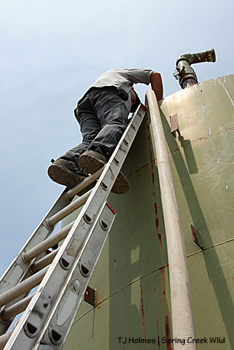
The storage tank is about 15 feet tall, so Cecil brings his ladder to access the hatch at the top. At right is the hose from his water truck.

062813watertank3

Seen here are his water truck, the hose to the tank and the water trough in the background at right.

062813watertank1

Thanks, Cecil! He also donated a load of water for the benefit’s silent auction. Cecil is a super nice man, and a friend of the mustangs of Spring Creek Basin.

Thank you, NMA/CO, for the delivery of water to the mustangs!


Fire tree update

19 07 2010

The tree fire is long out. While we’re scorching now in Southwest Colorado (and elsewhere – Denver hit 100 Saturday, even as did Cortez, straight south of the basin as the raven flies), we had rain awhile back, and it’s likely that doused the flames on the tree fire I reported almost two weeks ago.

The fire management officer from the Dolores Public Lands Office (who coordinates both Forest Service and BLM crews) was super nice and met me last week to make the long drive to the basin and have a look. What he could tell us would fill a book (and likely does somewhere, for aspiring young wildland firefighters), but the upshot is the basin would probably never suffer from a catastrophic wildfire because there simply are not the “combustibles” to fuel it (my word – I’m pretty sure he never said that actual word :)).

Here’s the “overall” scene. The tree that burned is fringed with brown on its needles – sort of middle/upper right. The dead branch in the foreground at right also burned, as well as the black stump you can barely make out just left of center, as well as some other branches that apparently were consumed by their respective fires. See the little green tree immediately behind the black stump? It’s hard to tell how close it is, but it’s close. That’s pinon – the tree that burned is Utah juniper (I also learned the difference between Rocky Mountain and Utah juniper) – and it wasn’t touched, apparently. But then see what looks like the dead, fallen trunk at far left? It’s attached to those singed needles you see at upper left (against the blue sky). That likely came from the fire, but the tree as a whole should live – even though it looks like it’s on the ground. So did the tree that burned before the fire burned through its horizontal trunk and put the “crown” on the ground, where it fell on another little bush with round little leaves … not a pinon or juniper. I imagine that poor little thing is toast. But hopefully you can also see in this picture, beneath the scattered woodsy debris (I’m surprised it didn’t burn), is grey dirt – which is sort of a mix of dirt and shaley rock – very fine – you can hear it crunch and crackle when you walk over it. And you can maybe get a sense of how far apart the trees are in this area. The FMO did note areas he thinks have burned previously, but grass may never take hold here – not well – because of the poor alkaline soil.

Between the near black stump (hard to see in the first picture) and the rest of the tree used to be the trunk, which burned completely and totally through and away. See where the bark of the tree looks skinned away? The FMO said that’s the path of the lightning strike. Not really a “scar” as much as it just burned from the top to the bottom through that “papery” layer of bark – basically, it’s “firestarter” – kindling.

Nature at work.

Be careful out there while you’re camping this summer. It seems like many places in the country are feeling the heat this summer, and particularly in the West, ’tis the season for fires – wild and otherwise. Some local Back Country Horsemen, out for a ride in the national forest close to where I live and have been mountain biking, were out for a day ride recently and came across a campfire someone(s) had left burning! (By the accompanying pictures, it was big.) Let’s have a collective gasp for the stupidity factor! Bless those horse folks for giving up ride time to not only put out the fire but CLEAN UP THE TRASH left behind! This was a possible disaster waiting to happen – many ponderosa pine trees and Gambel oak – forest – in other words, loaded with “fuel.” There are homes in the area, and it’s a popular recreation entry point to the forest for locals.

My thanks again to the FMO for coming out to the basin and enhancing my education about natural forces – which include fire. Here in the basin, the outcome was hopefully more benefit than disaster (maybe birds will make use of the tree as it decays … maybe some grasses will spring up in spite of the soil …). We even saw a few horses: Chrome’s band let us squeak by on the road pretty close, and Seven’s, Grey/Traveler’s and Hollywood’s were visible at distances in different areas.

Circle of life. 🙂


Fire on the hill

9 07 2010

My campfire? No. I never have a campfire in the basin.

A (live) tree on fire with several other pieces of nearby deadfall burning as well. Probably hit by lightning the night before. The first two photos are closer shots of the main trunk. It burned all the way through in the several hours I watched. Amazingly, I found cell service in the basin and called the Forest Service and was waiting for them to send somebody out … I finally had to leave – felt like I was leaving an “untended campfire.” I did scoop handfuls and handfuls of dirt onto every place that was burning, but it was like using a garden hose on an inferno – it just didn’t help at all. I ran into some government folks on my way home, and I think they were going to check it out or send someone(s). I had given directions and left a rock cairn at the road and rocks across the road and a rock arrow pointing directly to it … The good news was that the tree was only about a 5-minute hike from the road and was pretty well surrounded by dirt and shale-rock soil. I don’t know how or if it would spread once the fire reached the “crown,” which was then on the ground. There were about seven separate little fires burning from this one tree. Fairly near Wildcat Spring just above a horse trail. It was pretty disturbing to catch sight of smoke rising into the sky in a heavily treed section of my beloved basin! It was a very helpless feeling to not be able to do anything, hoping the dirt stopped the spread. I’ll be calling again and will hopefully update this post with “all out”!

UPDATE: The Forest Service fire folks are monitoring it from the air. There was no smoke from it today, apparently. Weather conditions are favorable to leave it alone. We did get rain in Durango this evening, so hopefully the basin is getting more rain as well.

UPDATE 2: I had a great chat with the fire management officer this morning. The herd area manager has flown over the area twice, he said, and the lookout at the Benchmark fire lookout tower (a wonderful, eagle-eyed woman I met last year when the tower got historic designation) is keeping an eye on it as well. And he may go out today to have a look at it on the ground. She (fire lookout) said a good rain swept over the area yesterday – yay! The FMO did tell me they would like to see fire play a natural role in the environment there, and of course, I recognize that and understand it and support it. Fire suppression is not the only job of FMOs – it’s also to calm nervous nellies like myself. 🙂 And, of course, to recognize not every fire has to be put out. My second year in Colorado, the Missionary Ridge Fire blew up north of Durango. The plumes of smoke were massive in the afternoon – just about the time I was driving in every day to work, up and over and down Hesperus Hill with just about the perfect view. It looked like a nuclear cloud signaling the end of the world. I realize how much it affected me THEN when I see smoke NOW. I have also seen blackened stumps all around – there’s one burned to the ground on the way to this tree (as well as a big pile of what I’m pretty sure is bear scat!). Can’t say it doesn’t still – or won’t again – freak me out to see smoke again some gentle morning after a thunderstorm – but “they’re all over it,” as they say. 🙂 Thank you!

UPDATE 3: The basin has apparently had some good, heavy rain, and the FMO doesn’t expect any spread from that fire. Part 2 is that maybe with the summer monsoons (they’re here, so says the press!), we’ll start seeing water hold in the ponds and other depressions in the basin, giving the horses better access to better water than stinky Wildcat Spring and salty hoof-print puddles. C’mon rain!